
Rohod topographic map
Interactive map
Click on the map to display elevation.
About this map
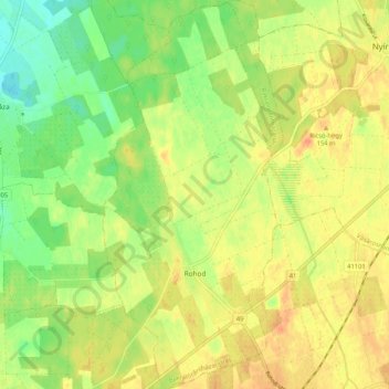
Name: Rohod topographic map, elevation, terrain.
Average elevation: 131 m
Minimum elevation: 110 m
Maximum elevation: 148 m
Other topographic maps
Click on a map to view its topography, its elevation and its terrain.
Ura
Hungary > Szabolcs-Szatmár-Bereg
Ura, Csengeri járás, Szabolcs-Szatmár-Bereg, North Great Plain, Great Plain and North, 4763, Hungary
Average elevation: 115 m
Kisar
Hungary > Szabolcs-Szatmár-Bereg > Kisar
Kisar, Fehérgyarmati járás, Szabolcs-Szatmár-Bereg, Great Plain and North, Hungary
Average elevation: 111 m