
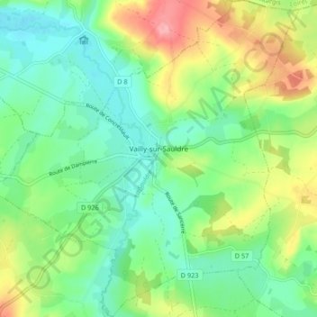
Vailly-sur-Sauldre topographic map
Interactive map
Click on the map to display elevation.
About this map
Name: Vailly-sur-Sauldre topographic map, elevation, terrain.
Average elevation: 223 m
Minimum elevation: 182 m
Maximum elevation: 304 m
Other topographic maps
Click on a map to view its topography, its elevation and its terrain.
Maisonnais
Frankrijk > Centre-Val de Loire > Cher
Maisonnais, Saint-Amand-Montrond, Cher, Centre-Val de Loire, Metropolitaans Frankrijk, 18170, Frankrijk
Average elevation: 218 m
Sévry
Frankrijk > Centre-Val de Loire > Cher
Sévry, Bourges, Cher, Centre-Val de Loire, Metropolitaans Frankrijk, 18140, Frankrijk
Average elevation: 203 m
Vierzon
Frankrijk > Centre-Val de Loire > Cher
Vierzon, Cher, Centre-Val de Loire, Metropolitaans Frankrijk, 18100, Frankrijk
Average elevation: 137 m
Sancerre
Frankrijk > Centre-Val de Loire > Cher
Sancerre, Bourges, Cher, Centre-Val de Loire, Metropolitaans Frankrijk, 18300, Frankrijk
Average elevation: 212 m
Bourges
Frankrijk > Centre-Val de Loire > Cher
Bourges, Cher, Centre-Val de Loire, Metropolitaans Frankrijk, 18000, Frankrijk
Average elevation: 146 m