
Alfter topographic map
Interactive map
Click on the map to display elevation.
About this map
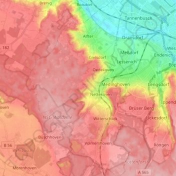
Name: Alfter topographic map, elevation, terrain.
Location: Alfter, Rhein-Sieg-Kreis, North Rhine-Westphalia, 53347, Germany (50.66144 6.95837 50.75658 7.04425)
Average elevation: 136 m
Minimum elevation: 52 m
Maximum elevation: 183 m
Other topographic maps
Click on a map to view its topography, its elevation and its terrain.
Hommerich
Germany > North Rhine-Westphalia > Rhein-Sieg-Kreis > Hennef (Sieg) > Hofen
Hommerich, Hofen, Hennef (Sieg), Rhein-Sieg-Kreis, North Rhine-Westphalia, 53773, Germany
Average elevation: 156 m
Walberberg
Germany > North Rhine-Westphalia > Rhein-Sieg-Kreis > Bornheim
Walberberg, Bornheim, Rhein-Sieg-Kreis, North Rhine-Westphalia, Germany
Average elevation: 101 m
Meckenheim
Germany > North Rhine-Westphalia > Rhein-Sieg-Kreis > Meckenheim > Meckenheim
Meckenheim, Rhein-Sieg-Kreis, North Rhine-Westphalia, 53340, Germany
Average elevation: 190 m
Swisttal
Germany > North Rhine-Westphalia > Rhein-Sieg-Kreis > Swisttal
Swisttal, Rhein-Sieg-Kreis, North Rhine-Westphalia, 53913, Germany
Average elevation: 154 m
Königswinter
Germany > North Rhine-Westphalia > Rhein-Sieg-Kreis
Königswinter, Rhein-Sieg-Kreis, North Rhine-Westphalia, 53639, Germany
Average elevation: 137 m