
Finsterwalde topographic map
Interactive map
Click on the map to display elevation.
About this map
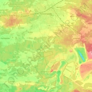
Name: Finsterwalde topographic map, elevation, terrain.
Location: Finsterwalde, Elbe-Elster, Brandenburg, 03238, Deutschland (51.51885 13.62882 51.65114 13.81499)
Average elevation: 113 m
Minimum elevation: 63 m
Maximum elevation: 167 m
Other topographic maps
Click on a map to view its topography, its elevation and its terrain.
Wildenau
Deutschland > Brandenburg > Elbe-Elster > Schönewalde
Wildenau, Schönewalde, Elbe-Elster, Brandenburg, Deutschland
Average elevation: 88 m
Doberlug-Kirchhain
Deutschland > Brandenburg > Elbe-Elster
Doberlug-Kirchhain, Elbe-Elster, Brandenburg, 03253, Deutschland
Average elevation: 106 m
Lichterfeld-Schacksdorf
Deutschland > Brandenburg > Elbe-Elster
Lichterfeld-Schacksdorf, Kleine Elster (Niederlausitz), Elbe-Elster, Brandenburg, Deutschland
Average elevation: 124 m