
Thank you for supporting this site ❤️
Make a donation
Make a donation
Douglas County topographic map
Click on the map to display elevation.
Thank you for supporting this site ❤️
Make a donation
Make a donation
About this map
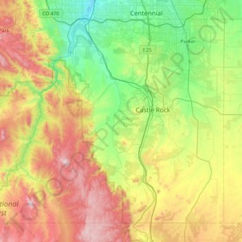
Name: Douglas County topographic map, elevation, terrain.
Location: Douglas County, Colorado, United States (39.12949 -105.32945 39.56648 -104.66061)
Average elevation: 2,104 m
Minimum elevation: 1,626 m
Maximum elevation: 2,975 m
Thank you for supporting this site ❤️
Make a donation
Make a donation
Other topographic maps
Click on a map to view its topography, its elevation and its terrain.
Colorado Springs
United States > Colorado > El Paso County > Colorado Springs
Snowfall is usually moderate and remains on the ground briefly because of direct sun, with the city receiving 38 inches (97 cm) per season, although the mountains to the west often receive in excess of triple that amount; March is the snowiest month in the region, both by total accumulation and number of days…
Average elevation: 2,229 m
Thank you for supporting this site ❤️
Make a donation
Make a donation