
Mont Blanc - Monte Bianco topographic map
Interactive map
Click on the map to display elevation.
About this map
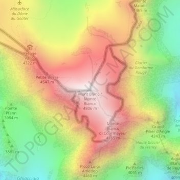
Name: Mont Blanc - Monte Bianco topographic map, elevation, terrain.
Average elevation: 4,092 m
Minimum elevation: 3,347 m
Maximum elevation: 4,804 m
De Mont Blanc (Frans voor witte berg, Italiaans: Monte Bianco) is de hoogste top van de Alpen, in het naar hem genoemde Mont Blancmassief. Na de Elbroes in de Kaukasus en enkele andere toppen in dat gebergte is het tevens de hoogste berg in Europa, westelijk van de Kaukasus. De Mont Blanc is 4807,81 meter hoog(september 2021), inclusief de sneeuw op de top. Zonder die sneeuw werd in 2004 een hoogte van 4792 meter bepaald.