
Newington topographic map
Interactive map
Click on the map to display elevation.
About this map
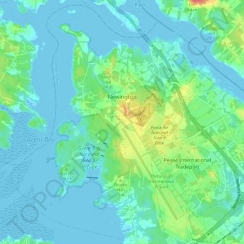
Name: Newington topographic map, elevation, terrain.
Location: Newington, Rockingham County, New Hampshire, United States (43.05903 -70.87996 43.12711 -70.78283)
Average elevation: 10 m
Minimum elevation: -7 m
Maximum elevation: 47 m
According to the United States Census Bureau, the town has a total area of 12.4 square miles (32.0 km2), of which 8.1 square miles (21.0 km2) are land and 4.2 square miles (11.0 km2) are water, comprising 34.5% of the town. The highest elevation in Newington is 130 feet (40 m) above sea level, near Newington Cemetery in the center of town.
Other topographic maps
Click on a map to view its topography, its elevation and its terrain.
Jenness Beach
United States > New Hampshire > Rockingham County > Rye > Rye Beach Village District
Jenness Beach, Rye Beach Village District, Rye, Rockingham County, New Hampshire, United States
Average elevation: 5 m
Northwood
United States > New Hampshire > Rockingham County
Northwood, Rockingham County, New Hampshire, 03261, United States
Average elevation: 167 m
Portsmouth
United States > New Hampshire > Rockingham County
Portsmouth, Rockingham County, New Hampshire, United States
Average elevation: 9 m
Stratham
United States > New Hampshire > Rockingham County
Stratham, Rockingham County, New Hampshire, 03885, United States
Average elevation: 22 m