
Pushpagiri WLS topographic map
Click on the map to display elevation.
About this map
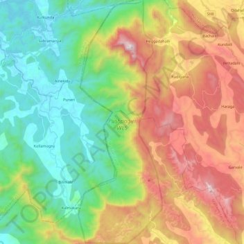
Name: Pushpagiri WLS topographic map, elevation, terrain.
Location: Pushpagiri WLS, Kodagu, Karnataka, India (12.49038 75.63846 12.70323 75.71385)
Average elevation: 720 m
Minimum elevation: 104 m
Maximum elevation: 1,706 m
Other topographic maps
Click on a map to view its topography, its elevation and its terrain.
Bengaluru
India > Karnataka > Bangalore North
Bengaluru (formerly Bangalore) is situated in the southeastern part of Karnataka, India, within the Bengaluru Urban district. It lies at an elevation of approximately 900 meters (3,000 feet) above sea level, on the Deccan Plateau. This elevated position gives the city a moderate climate, with temperatures…
Average elevation: 881 m
Mangaluru
India > Karnataka > Mangaluru taluk
Mangalore is also the administrative headquarters of the Dakshina Kannada district; it is a commercial, industrial, educational, healthcare, and startup hub. The city's international airport is the second-largest and second-busiest airport in Karnataka. Mangalore City Corporation is responsible for the civic…
Average elevation: 25 m
Madikeri
India > Karnataka > Madikeri taluku
Madikeri features a tropical highland climate as it has an elevation of 1,170 m (3,840 ft). Madikeri is located at 12°25′N 75°44′E / 12.42°N 75.73°E / 12.42; 75.73. Madikeri lies in the Western Ghats and is a popular hill station. The nearest cities are Hassan to the north, Mangaluru to the…
Average elevation: 1,054 m
Bannerghatta National Park
India > Karnataka > Harohalli taluk > Gullahatti Kaval
The 65,127.5 acre (260.51 km2) national park is located about 22 km south of Bangalore in the hills of the Anekal range with an elevation of 1245 - 1634m. The park has a hilly terrain of granite sheets under moist deciduous forest valleys and scrubland on higher areas. Sixteen villages border the park. Most of…
Average elevation: 782 m
Mysuru
India > Karnataka > Mysuru taluk
Mysore (/maɪˈsɔːr/ (listen)), officially Mysuru ([ˈmaɪˈsuːɾu] (listen)), is a city in the southern part of the state of Karnataka, India. Mysore city is geographically located between 12° 18′ 26″ north latitude and 76° 38′ 59″ east longitude. It is located at an altitude of 770 m (2,530 ft)…
Average elevation: 727 m
Bidar
Physiographically, the district can be divided into two regions, the northern low lands and southern high lands. The southern high lands are popularly known as Bidar plateau, which is made up of laterite. The ground altitudes are varying from 420 to 684 m (1,378 to 2,244 ft) above sea level. Bidar plateau has…
Average elevation: 576 m
Uttara Kannada
The district's high rainfall supports lush forests, which cover approximately 70% of the district. The Malabar Coast moist forests ecoregion lies in a narrow strip between the Arabian Sea and the foothills of the Western Ghats up to 250 meters elevation. These forests have been almost completely converted to…
Average elevation: 364 m
Malaprabha
The Malaprabha River (Kannada ಮಲಪ್ರಭಾ ನದಿ) is a tributary of the Krishna River and flows through the state of Karnataka in India.[citation needed] It rises in the Western Ghats at an elevation of 792.4 m (2,600 ft) in the state's Belgaum district. The river joins Krishna River at…
Average elevation: 608 m
Kalaburagi
Kalaburagi is situated in Deccan Plateau located at 17°20′N 76°50′E / 17.33°N 76.83°E / 17.33; 76.83 and the general elevation ranges from 300 to 750 meters above mean sea level. The main river is the Bhima.
Average elevation: 497 m
Ramanagara
Ramanagara is approximately 50 km southwest of Bangalore. The district shares borders with the districts of Bangalore Urban in the east, Bangalore Rural in the North-east, Tumakuru in the North-west, Mandya in the west and Chamarajanagara in the south-west and Krishnagiri district of Tamilnadu state in the…
Average elevation: 764 m
Ghataprabha
The source of the river can be identified from Phatakwadi Lake 15°56′22″N 74°03′34″E / 15.939335°N 74.059535°E / 15.939335; 74.059535, at an elevation of 750 metres above mean sea level.
Average elevation: 605 m
Coorg
Kodagu is located on the eastern slopes of the Western Ghats. It has a geographical area of 4,102 km2 (1,584 sq mi). The district is bordered by Dakshina Kannada district to the northwest, Hassan district to the north, Mysore district to the east, Kasaragod district of Kerala in west and Kannur district of…
Average elevation: 560 m
Manipal
India > Karnataka > Udupi taluku
Manipal is a suburb and university town within Udupi, in coastal Karnataka, India. Manipal is located five kilometres away from the centre of Udupi City, in Udupi District, Karnataka (state) in south western India. It is administered by the Udupi City Municipality. The suburb is located in coastal Karnataka,…
Average elevation: 32 m
Sirsi
India > Karnataka > Shirasi taluk
Sirsi is located at 14°37′N 74°51′E / 14.62°N 74.85°E / 14.62; 74.85 (Grid Square MK74).[3] It has an elevation ranging between 1860 feet to 2600 feet above sea level, and is situated in the heart of the Western Ghats. Sirsi is about 399 kilometres (248 mi) from Bangalore. The nearest airport…
Average elevation: 556 m
Chintamani
India > Karnataka > Chintamani taluk
Chintamani lies in the southeast of the South Indian state of Karnataka. It is in the heart of the Mysore Plateau at an average elevation of 865 m (2,838 ft). The Taluk geographically lies between 78°12′36″N 13°16′38″E / 78.21000°N 13.27722°E / 78.21000; 13.27722 and 77°51′39″N…
Average elevation: 886 m
Bengaluru
India > Karnataka > Bangalore North
Bengaluru lies in the southeast of the South Indian state of Karnataka in the heart of the Mysore Plateau (a region of the larger Deccan Plateau) at an average elevation of 900 m (2,953 ft). The city covers an area of 741 km2 (286 sq mi). The Bengaluru metropolitan region covers an area of 7,005 km2 (2,705 sq…
Average elevation: 879 m
Chikkamagaluru
India > Karnataka > Chikkamagaluru taluku
Chikmagalur is situated in the Malenadu region of Karnataka in the Deccan plateau in the foothills of the Western Ghats. It is situated at an elevation of 1,090 metres (3,580 ft) above mean sea level, meaning, it is the third highest city in Karnataka. The Yagachi River has its source near the town and flows…
Average elevation: 1,052 m