
Thank you for supporting this site ❤️
Make a donation
Make a donation
State Line topographic map
Click on the map to display elevation.
Thank you for supporting this site ❤️
Make a donation
Make a donation
About this map
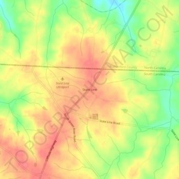
Name: State Line topographic map, elevation, terrain.
Location: State Line, Cherokee County, South Carolina, United States (35.15679 -81.82010 35.19679 -81.78010)
Average elevation: 266 m
Minimum elevation: 227 m
Maximum elevation: 291 m
Thank you for supporting this site ❤️
Make a donation
Make a donation
Other topographic maps
Click on a map to view its topography, its elevation and its terrain.
Cherokee Falls
United States > South Carolina > Cherokee County > Cherokee Falls
Average elevation: 186 m
Blacksburg
United States > South Carolina > Cherokee County
Whitaker Mountain is partially in the northern corner of the town, with a summit elevation outside the town limits of approximately 1,169 ft (356 m).
Average elevation: 228 m