
Tamia topographic map
Interactive map
Click on the map to display elevation.
About this map
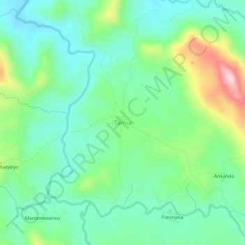
Name: Tamia topographic map, elevation, terrain.
Location: Tamia, Haute Matsiatra, Province de Fianarantsoa, Madagascar (-21.86673 46.67891 -21.82673 46.71891)
Average elevation: 979 m
Minimum elevation: 881 m
Maximum elevation: 1,224 m
Other topographic maps
Click on a map to view its topography, its elevation and its terrain.
Fianarantsoa
Madagascar > Haute Matsiatra > District de Fianarantsoa
It is at an average altitude of 1,200 metres (3,900 ft), and has a population of 191,766.
Average elevation: 1,172 m