
Thank you for supporting this site ❤️
Make a donation
Make a donation
Chulafinnee topographic map
Click on the map to display elevation.
Thank you for supporting this site ❤️
Make a donation
Make a donation
About this map
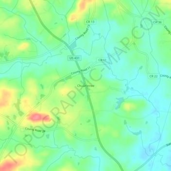
Name: Chulafinnee topographic map, elevation, terrain.
Location: Chulafinnee, Cleburne County, Alabama, United States (33.52539 -85.66885 33.56539 -85.62885)
Average elevation: 269 m
Minimum elevation: 244 m
Maximum elevation: 321 m
Thank you for supporting this site ❤️
Make a donation
Make a donation
Other topographic maps
Click on a map to view its topography, its elevation and its terrain.