
Thank you for supporting this site ❤️
Make a donation
Make a donation
Saint-Paulien topographic map
Click on the map to display elevation.
Thank you for supporting this site ❤️
Make a donation
Make a donation
Saint-Paulien
Saint-Paulien fait partie du Velay. Située à 810 mètres d'altitude, elle détient le titre de capitale du Velay depuis son âge d'or il y a 2 000 ans.
Thank you for supporting this site ❤️
Make a donation
Make a donation
About this map
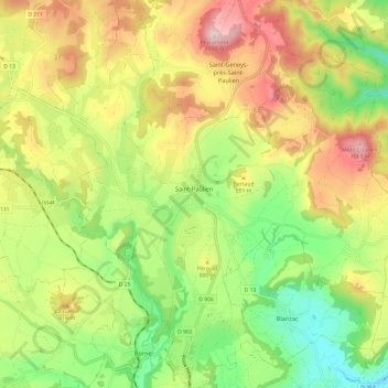
Name: Saint-Paulien topographic map, elevation, terrain.
Average elevation: 841 m
Minimum elevation: 638 m
Maximum elevation: 1,096 m
Thank you for supporting this site ❤️
Make a donation
Make a donation
Other topographic maps
Click on a map to view its topography, its elevation and its terrain.
Le Croizet
France > Auvergne-Rhône-Alpes > Haute-Loire > Saint-Privat-du-Dragon
Average elevation: 644 m
La Biela
France > Auvergne-Rhône-Alpes > Haute-Loire > Saint-Ferréol-d'Auroure
Average elevation: 655 m
Thank you for supporting this site ❤️
Make a donation
Make a donation