
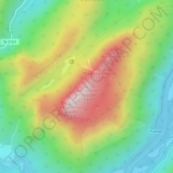
Rabensteinhorn Nordgipfel topographic map
Interactive map
Click on the map to display elevation.
About this map
Name: Rabensteinhorn Nordgipfel topographic map, elevation, terrain.
Average elevation: 827 m
Minimum elevation: 484 m
Maximum elevation: 1,329 m
Other topographic maps
Click on a map to view its topography, its elevation and its terrain.
Weißbach
Deutschland > Bayern > Landkreis Berchtesgadener Land > Bad Reichenhall
Weißbach, Bad Reichenhall, Landkreis Berchtesgadener Land, Bayern, 83435, Deutschland
Average elevation: 525 m
Nonn
Deutschland > Bayern > Landkreis Berchtesgadener Land > Bad Reichenhall
Nonn, Bad Reichenhall, Landkreis Berchtesgadener Land, Bayern, 83457, Deutschland
Average elevation: 709 m
Predigtstuhl
Deutschland > Bayern > Landkreis Berchtesgadener Land > Bad Reichenhall
Predigtstuhl, Bad Reichenhall, Landkreis Berchtesgadener Land, Bayern, 83457, Deutschland
Average elevation: 1,162 m
Thumsee
Deutschland > Bayern > Landkreis Berchtesgadener Land > Bad Reichenhall > Thumsee
Thumsee, Bad Reichenhall, Landkreis Berchtesgadener Land, Bayern, Deutschland
Average elevation: 733 m