
Fillinges topographic map
Interactive map
Click on the map to display elevation.
About this map
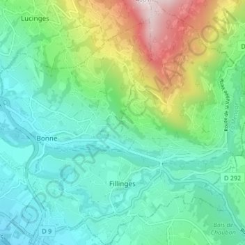
Name: Fillinges topographic map, elevation, terrain.
Average elevation: 682 m
Minimum elevation: 460 m
Maximum elevation: 1,306 m
Le chef-lieu du village se trouve à 572 m d'altitude. Le village se trouve à 7,4 km d'Annemasse.
Other topographic maps
Click on a map to view its topography, its elevation and its terrain.
Pont de Fillinges
France > Auvergne-Rhône-Alpes > Haute-Savoie > Fillinges
Pont de Fillinges, Fillinges, Saint-Julien-en-Genevois, Haute-Savoie, Auvergne-Rhône-Alpes, France métropolitaine, 74250, France
Average elevation: 650 m