
Provincia de Örebro topographic map
Interactive map
Click on the map to display elevation.
About this map
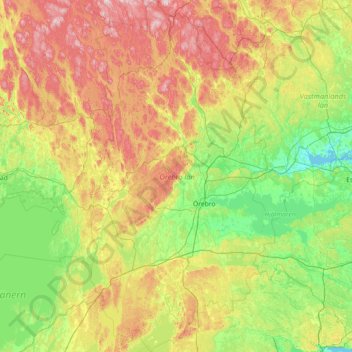
Name: Provincia de Örebro topographic map, elevation, terrain.
Location: Provincia de Örebro, Svealand, Suecia (58.64623 14.28523 60.11087 15.79853)
Average elevation: 122 m
Minimum elevation: -1 m
Maximum elevation: 466 m
Other topographic maps
Click on a map to view its topography, its elevation and its terrain.
Kumla kommun
Kumla kommun, Provincia de Örebro, Svealand, Suecia
Average elevation: 65 m
Ljusnarsbergs kommun
Ljusnarsbergs kommun, Provincia de Örebro, Svealand, Suecia
Average elevation: 253 m
Lekeberg
Lekeberg, Landskapet Närke, Provincia de Örebro, Svealand, Suecia
Average elevation: 103 m
Örebro
Örebro, Landskapet Närke, Provincia de Örebro, Svealand, Suecia
Average elevation: 73 m