
Thank you for supporting this site ❤️
Make a donation
Make a donation
Weuspert topographic map
Click on the map to display elevation.
Thank you for supporting this site ❤️
Make a donation
Make a donation
Weuspert
Der Ort liegt auf einer Höhe zwischen etwa 480 und 500 m über NN im Naturpark Sauerland-Rothaargebirge. Die Kreisstraße 29 führt durch den Ort. Auch der Wanderweg Sauerland-Höhenflug berührt den Ort. Häufig werden unter dem Namen Weuspert auch noch die in unmittelbarer Nachbarschaft liegenden Weiler Wörden, Faulebutter und Klingelborn zusammengefasst.
Thank you for supporting this site ❤️
Make a donation
Make a donation
About this map
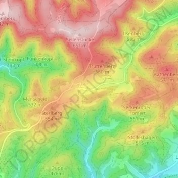
Name: Weuspert topographic map, elevation, terrain.
Average elevation: 486 m
Minimum elevation: 315 m
Maximum elevation: 650 m
Thank you for supporting this site ❤️
Make a donation
Make a donation
Other topographic maps
Click on a map to view its topography, its elevation and its terrain.