
Pepin Island topographic map
Interactive map
Click on the map to display elevation.
About this map
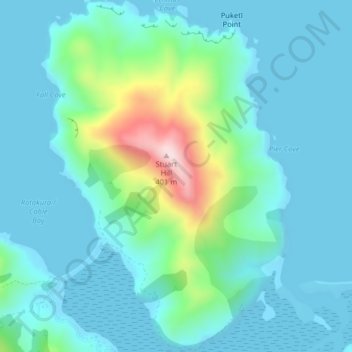
Name: Pepin Island topographic map, elevation, terrain.
Location: Pepin Island, Nelson, New Zealand (-41.16671 173.41150 -41.13636 173.44482)
Average elevation: 69 m
Minimum elevation: 0 m
Maximum elevation: 395 m
Other topographic maps
Click on a map to view its topography, its elevation and its terrain.
Dew Lakes
New Zealand > Nelson > Nelson
Dew Lakes, Saddle Hill Route, Nelson, New Zealand
Average elevation: 800 m
Wakapuaka River
New Zealand > Nelson > Nelson
Wakapuaka River, Nelson, 7071, New Zealand
Average elevation: 164 m
Whangamoa River
New Zealand > Nelson > Nelson
Whangamoa River, Nelson, New Zealand
Average elevation: 225 m