
Albertacce topographic map
Interactive map
Click on the map to display elevation.
Albertacce
The western slopes of the valley are covered by the communal forest of Albertacce composed mainly of Corsican pine. The pine is called lariciu ("a large" in Corsican language) is part of the large family of black pines. It can occur at altitudes between 1000 and 1800 m on sunny slopes. There are nuthatches, non-migratory birds which live on the tree trunks moving head down. There are 2,000 pairs in Corsica.
About this map
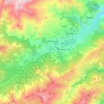
Name: Albertacce topographic map, elevation, terrain.
Average elevation: 1,360 m
Minimum elevation: 573 m
Maximum elevation: 2,577 m
Other topographic maps
Click on a map to view its topography, its elevation and its terrain.
Faubourg Scarafaglie
France > Corsica > Haute-Corse > Corte > Faubourg Scarafaglie
Average elevation: 580 m