
Make a donation
Perm Krai topographic map
Click on the map to display elevation.
Make a donation
About this map
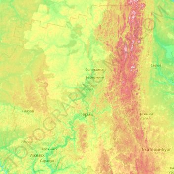
Name: Perm Krai topographic map, elevation, terrain.
Location: Perm Krai, Volga Federal District, Russia (56.10524 51.77238 61.66323 59.48251)
Average elevation: 222 m
Minimum elevation: 58 m
Maximum elevation: 1,326 m
Make a donation
Other topographic maps
Click on a map to view its topography, its elevation and its terrain.
Greater Caucasus
Russia > Kabardino-Balkaria Republic > Elbrus District
Most of the border of Russia with Georgia and Azerbaijan runs along most of the Caucasus' length. The Georgian Military Road (Darial Gorge) and Trans-Caucasus Highway traverse this mountain range at altitudes of up to 3,000 metres (9,800 ft).
Average elevation: 5,128 m
Make a donation
Siberia
Russia > Krasnoyarsk Krai > Boguchansky Rayon
Eastern and central Sakha comprises numerous north–south mountain ranges of various ages. These mountains extend up to almost 3,000 metres (9,800 ft), but above a few hundred metres they are almost completely devoid of vegetation. The Verkhoyansk Range was extensively glaciated in the Pleistocene, but the…
Average elevation: 346 m
Make a donation
Make a donation
Make a donation
Make a donation
Make a donation
Batagaika crater
Russia > Sakha Republic > Verkhoyansky Ulus
According to a conference paper published in 2016 the crater did not show any signs of stabilization after several decades (since 1980s) of slump growth, with the headwall retreating with observed rates of generally >10 m and up to 30 m per year closer to 2016. Reconstruction of a paleo-surface revealed that…
Average elevation: 279 m
Make a donation
Make a donation
Make a donation
Make a donation
Make a donation
Kazbegi
Russia > Republic of North Ossetia – Alania > Prigorodny District
Kazbek is located on the Khokh Range, a mountain range which runs north of the Greater Caucasus Range, and which is pierced by the gorges of the Ardon and the Terek. At its eastern foot runs the Georgian Military Road through the pass of Darial 2,378 meters (7,805 feet). The mountain itself lies along the edge…
Average elevation: 4,324 m
Make a donation
Патриарх
Russia > Krasnodar Krai > Resort Town of Sochi (municipal formation) > Sochi
Average elevation: 3 m
Make a donation
Make a donation
Make a donation
Kane Island
Russia > Arkhangelsk Oblast > Primorsky District
The largely unglacierised Kane island has a maximum altitude of 282 m (925 ft). It is about 5.8 km (3.6 mi) in length, measured from north to south. The northeastern tip is called Cape Hellwald (Russian: мыс Гельвальда) while Cape Easter (Russian: мыс Пасхи) is in the southeast.
Average elevation: 79 m
Taiga
Russia > Kemerovo Oblast–Kuzbass > Тайгинский городской округ > Taiga
Although at high elevations taiga grades into alpine tundra through Krummholz, it is not exclusively an alpine biome, and unlike subalpine forest, much of taiga is lowlands.
Average elevation: 249 m
Vanino
Russia > Khabarovsk Krai > Vaninsky Rayon
Vanin Bay on the Strait of Tartary was named after a topographer who worked in a team that prepared maps of the coast in 1874. Vanino was established in 1907.
Average elevation: 57 m
Make a donation
Make a donation
Make a donation
Make a donation
Make a donation
Make a donation
Great Neva
Russia > Saint Petersburg > Saint Petersburg
The Neva flows out of Lake Ladoga near Shlisselburg, flows through Neva's lowlands and discharges into the Baltic Sea in the Gulf of Finland. It has a length of 74 kilometres (46 mi), and the shortest distance from the source to the mouth is 45 kilometres (28 mi). The river banks are low and steep, on average…
Average elevation: 8 m
Make a donation
Make a donation
Make a donation
Make a donation