
Make a donation
Hisor District topographic map
Click on the map to display elevation.
Make a donation
About this map
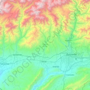
Name: Hisor District topographic map, elevation, terrain.
Location: Hisor District, 735020, Tajikistan (38.34229 68.47841 38.92661 68.68521)
Average elevation: 1,588 m
Minimum elevation: 630 m
Maximum elevation: 4,386 m
Make a donation
Other topographic maps
Click on a map to view its topography, its elevation and its terrain.
Khorugh
Tajikistan > Gorno-Badakhshan Autonomous Region > Shughnon District
Khorog is the locality of highest altitude where bandy has been played.
Average elevation: 2,636 m
Ismoil Somoni
Tajikistan > Gorno-Badakhshan Autonomous Region > Murghob District
In 1928, the long-term Tajik-Pamir expedition of the Academy of Sciences of the USSR began to operate, which began with the Soviet-German expedition with the participation of Willi Rickmers. As a result of topographic survey, it was found that one of the peaks visible in the west of the Fedchenko glaciers…
Average elevation: 6,554 m
Make a donation
Pamir Mountains
Tajikistan > Gorno-Badakhshan Autonomous Region > Murghob District
Average elevation: 6,355 m
Pamir Mountains
Tajikistan > Gorno-Badakhshan Autonomous Region > Murghob District
Average elevation: 6,355 m
Make a donation
Pamir Mountains
Tajikistan > Gorno-Badakhshan Autonomous Region > Murghob District
Average elevation: 6,355 m
Independence Peak
Tajikistan > Gorno-Badakhshan Autonomous Region > Rushon District
Average elevation: 6,376 m
Make a donation
Bulunkul
Tajikistan > Gorno-Badakhshan Autonomous Region > Murghob District > Bulunkul
Average elevation: 3,763 m
Jizev Valley
Tajikistan > Gorno-Badakhshan Autonomous Region > Rushon District
Average elevation: 2,948 m
Bibi Fatima
Tajikistan > Gorno-Badakhshan Autonomous Region > Ishkoshim District > Yamchun
Average elevation: 3,431 m
Make a donation
Ismoil Somoni
Tajikistan > Gorno-Badakhshan Autonomous Region > Murghob District
In 1928, the long-term Tajik-Pamir expedition of the Academy of Sciences of the USSR began to operate, which began with the Soviet-German expedition with the participation of Willi Rickmers. As a result of topographic survey, it was found that one of the peaks visible in the west of the Fedchenko glaciers…
Average elevation: 6,554 m
Make a donation
Pamir Mountains
Tajikistan > Gorno-Badakhshan Autonomous Region > Murghob District
Average elevation: 6,355 m
Pamir Mountains
Tajikistan > Gorno-Badakhshan Autonomous Region > Murghob District
Average elevation: 6,355 m
Make a donation