
Thank you for supporting this site ❤️
Make a donation
Make a donation
Gheen topographic map
Click on the map to display elevation.
Thank you for supporting this site ❤️
Make a donation
Make a donation
About this map
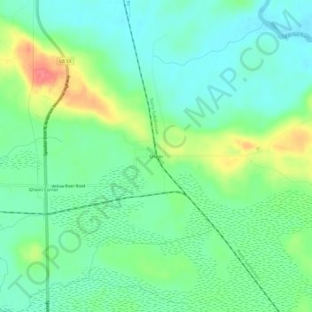
Name: Gheen topographic map, elevation, terrain.
Location: Gheen, Saint Louis County, Minnesota, United States (47.94797 -92.82823 47.98797 -92.78823)
Average elevation: 411 m
Minimum elevation: 388 m
Maximum elevation: 462 m
Thank you for supporting this site ❤️
Make a donation
Make a donation