
Governorate of Jidda topographic map
Interactive map
Click on the map to display elevation.
About this map
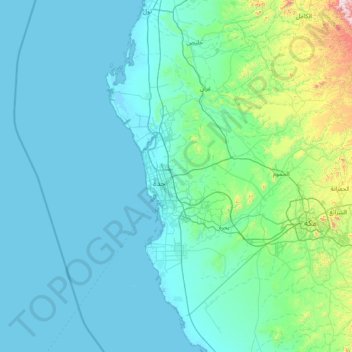
Name: Governorate of Jidda topographic map, elevation, terrain.
Location: Governorate of Jidda, Makkah Region, Saudi Arabia (20.89160 38.93004 22.32284 39.45421)
Average elevation: 130 m
Minimum elevation: -2 m
Maximum elevation: 1,609 m
Other topographic maps
Click on a map to view its topography, its elevation and its terrain.
Mecca
Saudi Arabia > Makkah Region > Mecca
Mecca is at an elevation of 277 m (909 ft) above sea level, and approximately 80 km (50 mi) inland from the Red Sea. Central Mecca lies in a corridor between mountains, which is often called the "Hollow of Mecca". The area contains the valley of Al Taneem, the Valley of Bakkah and the valley of Abqar. This…
Average elevation: 313 m