
Hühnerberg topographic map
Interactive map
Click on the map to display elevation.
About this map
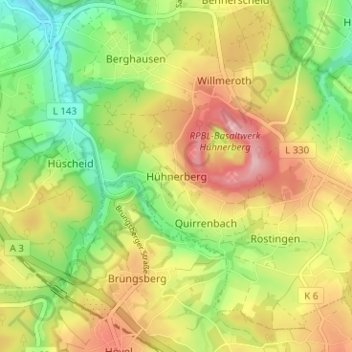
Name: Hühnerberg topographic map, elevation, terrain.
Average elevation: 214 m
Minimum elevation: 131 m
Maximum elevation: 305 m
Other topographic maps
Click on a map to view its topography, its elevation and its terrain.
Siebengebirge
Deutschland > Nordrhein-Westfalen > Rhein-Sieg-Kreis > Königswinter
Siebengebirge, Königswinter, Rhein-Sieg-Kreis, Nordrhein-Westfalen, Deutschland
Average elevation: 166 m