
Thank you for supporting this site ❤️
Make a donation
Make a donation
Essen topographic map
Click on the map to display elevation.
Thank you for supporting this site ❤️
Make a donation
Make a donation
Essen
The lowest point can be found in the northern borough of Karnap at 26.5 m (86.9 ft), the highest point in the borough of Heidhausen at 202.5 m (664 ft). The average elevation is 116 m (381 ft).
Thank you for supporting this site ❤️
Make a donation
Make a donation
About this map
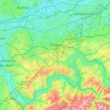
Name: Essen topographic map, elevation, terrain.
Location: Essen, North Rhine-Westphalia, Germany (51.34757 6.89434 51.53423 7.13765)
Average elevation: 86 m
Minimum elevation: 27 m
Maximum elevation: 254 m
Thank you for supporting this site ❤️
Make a donation
Make a donation