
Wayang-Windu topographic map
Interactive map
Click on the map to display elevation.
About this map
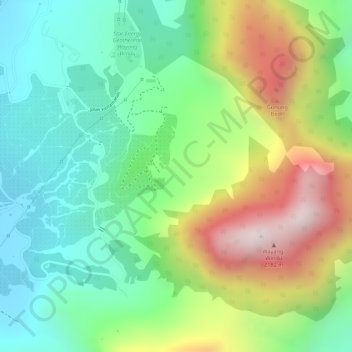
Name: Wayang-Windu topographic map, elevation, terrain.
Location: Wayang-Windu, Bandung, West-Java, Indonesien (-7.20805 107.62995 -7.20795 107.63005)
Average elevation: 1,795 m
Minimum elevation: 1,557 m
Maximum elevation: 2,175 m
Other topographic maps
Click on a map to view its topography, its elevation and its terrain.
Rancabolang
Indonesien > West-Java > Bandung
Rancabolang, Gedebage, Bandung, West-Java, Jawa, Indonesien
Average elevation: 664 m
Papandayan
Indonesien > West-Java > Bandung
Papandayan, Bandung, West-Java, Indonesien
Average elevation: 2,319 m
Gunung Kendang
Indonesien > West-Java > Bandung
Gunung Kendang, Bandung, West-Java, Indonesien
Average elevation: 2,284 m
Gunung Patuha
Indonesien > West-Java > Bandung
Gunung Patuha, Bandung, West-Java, 40973, Indonesien
Average elevation: 2,103 m
Kamojang, Kawah
Indonesien > West-Java > Bandung
Kamojang, Kawah, Bandung, West-Java, Indonesien
Average elevation: 1,589 m