
El Rama (Municipio) topographic map
Interactive map
Click on the map to display elevation.
About this map
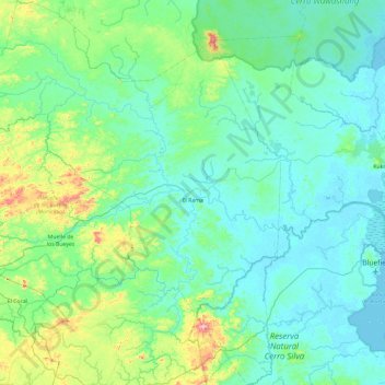
Name: El Rama (Municipio) topographic map, elevation, terrain.
Location: El Rama (Municipio), South Caribbean Coast, 82300, Nicaragua (11.72007 -84.80112 12.63881 -84.00423)
Average elevation: 84 m
Minimum elevation: -1 m
Maximum elevation: 607 m
Other topographic maps
Click on a map to view its topography, its elevation and its terrain.
Managua
Managua, due to its tropical climate, varied topography, naturally fertile soils, and abundant rain and water sources, boasts a great variety of flora. Many different types of trees, some of which are not found elsewhere in the world, appear, including chilamates, ceibos, pochotes, genízaros, tigüilotes,…
Average elevation: 194 m