
Thank you for supporting this site ❤️
Make a donation
Make a donation
Chickasha topographic map
Click on the map to display elevation.
Thank you for supporting this site ❤️
Make a donation
Make a donation
About this map
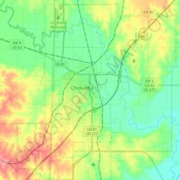
Name: Chickasha topographic map, elevation, terrain.
Location: Chickasha, Grady County, Oklahoma, United States (34.97129 -98.00531 35.10940 -97.85529)
Average elevation: 350 m
Minimum elevation: 318 m
Maximum elevation: 407 m
Thank you for supporting this site ❤️
Make a donation
Make a donation
Other topographic maps
Click on a map to view its topography, its elevation and its terrain.