
Thank you for supporting this site ❤️
Make a donation
Make a donation
Burgh St. Peter topographic map
Click on the map to display elevation.
Thank you for supporting this site ❤️
Make a donation
Make a donation
About this map
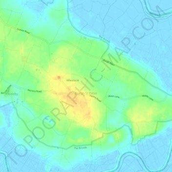
Name: Burgh St. Peter topographic map, elevation, terrain.
Location: Burgh St. Peter, South Norfolk, Norfolk, England, United Kingdom (52.46781 1.62972 52.50403 1.68263)
Average elevation: 9 m
Minimum elevation: -2 m
Maximum elevation: 28 m
Thank you for supporting this site ❤️
Make a donation
Make a donation
Other topographic maps
Click on a map to view its topography, its elevation and its terrain.