
Charleroi topographic map
Interactive map
Click on the map to display elevation.
About this map
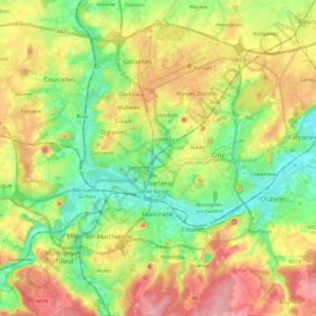
Name: Charleroi topographic map, elevation, terrain.
Location: Charleroi, Hennegau, Wallonien, Belgien (50.35284 4.34811 50.49243 4.50755)
Average elevation: 152 m
Minimum elevation: 92 m
Maximum elevation: 233 m
Other topographic maps
Click on a map to view its topography, its elevation and its terrain.
Fontaine-l'Évêque
Belgien > Hennegau > Charleroi > Fontaine-l'Évêque
Fontaine-l'Évêque, Charleroi, Hennegau, Wallonien, 6140, Belgien
Average elevation: 162 m