
Tamworth topographic map
Interactive map
Click on the map to display elevation.
About this map
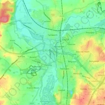
Name: Tamworth topographic map, elevation, terrain.
Location: Tamworth, Staffordshire, Engeland, Verenigd Koninkrijk (52.58867 -1.73582 52.65750 -1.63293)
Average elevation: 76 m
Minimum elevation: 47 m
Maximum elevation: 130 m
Other topographic maps
Click on a map to view its topography, its elevation and its terrain.
Burton-on-Trent
Verenigd Koninkrijk > Engeland > Staffordshire > East Staffordshire
Burton-on-Trent, East Staffordshire, Staffordshire, Engeland, DE14 1JN, Verenigd Koninkrijk
Average elevation: 69 m
Gun
Verenigd Koninkrijk > Engeland > Staffordshire > Staffordshire Moorlands
Gun, Staffordshire Moorlands, Staffordshire, West Midlands, Engeland, SK11 0SW, Verenigd Koninkrijk
Average elevation: 286 m
Leek
Verenigd Koninkrijk > Engeland > Staffordshire > Staffordshire Moorlands
Leek, Staffordshire Moorlands, Staffordshire, Engeland, Verenigd Koninkrijk
Average elevation: 193 m