
Make a donation
Bishkek City topographic map
Click on the map to display elevation.
Make a donation
Bishkek City
Bishkek is situated at an altitude of about 800 metres (2,600 ft), just off the northern fringe of the Kyrgyz Ala-Too Range, an extension of the Tian Shan mountain range. These mountains rise to a height of 4,895 metres (16,060 ft). North of the city, a fertile and gently undulating steppe extends far north into neighboring Kazakhstan. The river Chüy drains most of the area. Bishkek is connected to the Turkestan–Siberia Railway by a spur line.
Make a donation
About this map
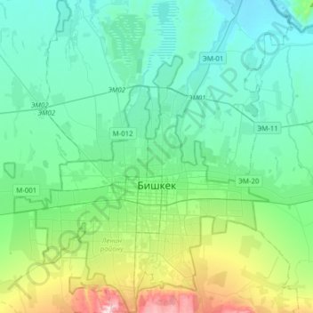
Name: Bishkek City topographic map, elevation, terrain.
Location: Bishkek City, Kyrgyzstan (42.71555 74.45489 43.01250 74.71772)
Average elevation: 867 m
Minimum elevation: 628 m
Maximum elevation: 1,854 m
Make a donation
Other topographic maps
Click on a map to view its topography, its elevation and its terrain.
Make a donation
Make a donation
Make a donation
Ala-Köl
Kyrgyzstan > Issyk-Kul Region > Ak-Suu District
Ala-Köl (Kyrgyz: Ала-Көл, also Алакөл, Russian: Ала-Куль, romanized: Ala-Kul) is a rock-dammed lake in the Terskey Alatau mountain range in the Ak-Suu District of the Issyk-Kul Region in Kyrgyzstan. It lies at an altitude of 3,532 m (11,588 ft). It is 2.8 km (1.7 mi) long and 600–700 m…
Average elevation: 3,703 m
Make a donation
Khan Tengri
Kyrgyzstan > Issyk-Kul Region > Ak-Suu District
Khan Tengri is a mountain of the Tian Shan mountain range in Central Asia. It is on the China—Kyrgyzstan—Kazakhstan tripoint, east of lake Issyk Kul. Its geologic elevation is 6,995 m (22,949 ft), but its glacial icecap rises to 7,010 m (22,999 ft). For this reason, in mountaineering circles, including for…
Average elevation: 5,894 m
Jengish Chokusu
Kyrgyzstan > Issyk-Kul Region > Ak-Suu District
Jengish Chokusu or Victory Peak is the highest mountain in the Tian Shan mountain system in Central Asia at 7,439 metres (24,406 ft). It lies on the China–Kyrgyzstan border between the Ak-Suu District in the Issyk-Kul Region of far Eastern Kyrgyzstan and Wensu County, Xinjiang, China. It is part of the…
Average elevation: 6,681 m
Make a donation
Barskoon
Kyrgyzstan > Issyk-Kul Region > Jeti-Ögüz District
In the mountains to the south-east is a region known as syrt - an "alpine cold desert" located at average altitudes around 3,600 m (11,800 ft). A364, one of the few good roads into the mountains in southern Issyk-Kul Region, goes south down the valley, over the Barskoon and Söök Passes to Kara-Say in the…
Average elevation: 1,773 m
Make a donation
Tash-Rabat
Kyrgyzstan > Naryn Region > At-Bashy District > Таш-Рабат
Tash Rabat is a well-preserved 15th-century stone caravanserai in At-Bashy District, Naryn Province, Kyrgyzstan, located at an altitude of 3,200 metres (10,500 ft).
Average elevation: 3,300 m
Make a donation
Lenin Peak
Kyrgyzstan > Osh Region > Chong-Alay District
Local Kyrgyz names include Jel-Aidar ("Wind's God") and Achyk-Tash ("Open Rock"). Achik-Tash, is also the name of a plateau and a base camp at an elevation of 3,600 m on a popular northern climbing route to Lenin Peak, which starts in the southern Kyrgyz city of Osh, a day's drive north of the border. Another…
Average elevation: 6,567 m
Make a donation
Make a donation
Make a donation
Make a donation
Chong-Kemin River
Kyrgyzstan > Chuy Region > Кеминский район - Кемин району
Average elevation: 3,254 m
Make a donation
Make a donation