
Banyuwangi topographic map
Interactive map
Click on the map to display elevation.
About this map
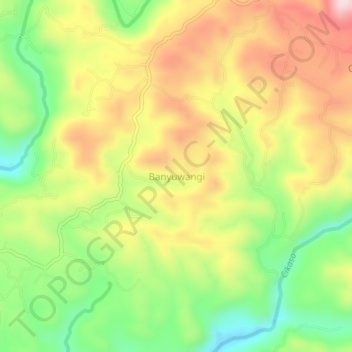
Name: Banyuwangi topographic map, elevation, terrain.
Location: Banyuwangi, Sukabumi, Java occidental, Indonésie (-7.33577 106.65372 -7.29577 106.69372)
Average elevation: 199 m
Minimum elevation: 42 m
Maximum elevation: 365 m
Other topographic maps
Click on a map to view its topography, its elevation and its terrain.
Batununggal
Indonésie > Java occidental > Sukabumi
Batununggal, Sukabumi, Java occidental, Jawa, 43351, Indonésie
Average elevation: 500 m