
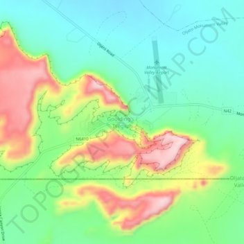
Goulding's / Tségiizh topographic map
Interactive map
Click on the map to display elevation.
About this map
Name: Goulding's / Tségiizh topographic map, elevation, terrain.
Average elevation: 1,634 m
Minimum elevation: 1,535 m
Maximum elevation: 1,813 m
Other topographic maps
Click on a map to view its topography, its elevation and its terrain.
Colorado-Plateau
Vereinigte Staaten von Amerika > Utah > San Juan County
Colorado-Plateau, Western Navajo Agency / Tó Naneesdizí Bił Hahoodzo biyiʼdi, San Juan County, Utah, Vereinigte Staaten von Amerika
Average elevation: 1,512 m
Mexican Hat
Vereinigte Staaten von Amerika > Utah > San Juan County
Mexican Hat, San Juan County, Utah, Vereinigte Staaten von Amerika
Average elevation: 1,346 m
Lake Powell
Vereinigte Staaten von Amerika > Utah > San Juan County
Lake Powell, San Juan County, Utah, Vereinigte Staaten von Amerika
Average elevation: 1,555 m