
Door County topographic map
Interactive map
Click on the map to display elevation.
About this map
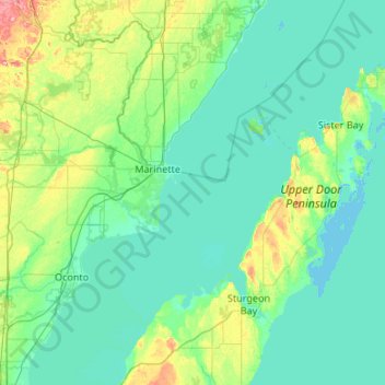
Name: Door County topographic map, elevation, terrain.
Location: Door County, Wisconsin, United States of America (44.67496 -87.73686 45.42985 -86.76396)
Average elevation: 191 m
Minimum elevation: 172 m
Maximum elevation: 315 m
The 102 ft high Brussels Hill (44°45′06″N 87°35′27″W / 44.75166°N 87.59093°W / 44.75166; -87.59093 (Brussels Hill), elevation 851 feet) is the highest point in the county. It has been explained as the result of a meteorite impact. The hill is missing blocks of rock ripped off during glaciation. The broken rocks leave behind nearly horizontal and vertical rock surfaces along the pre-existing weaknesses (beds and joints) in the rock. This is considered a feature of glaciokarst geology. The nearby Red Hill Woods is the largest remaining maple–beech forest in the area.
Other topographic maps
Click on a map to view its topography, its elevation and its terrain.
Middleton
United States of America > Wisconsin > Middleton
Middleton, Wisconsin, 53562, United States of America
Average elevation: 297 m
Walworth County
United States of America > Wisconsin
Walworth County, Wisconsin, United States of America
Average elevation: 282 m
Dodgeville
United States of America > Wisconsin > Dodgeville
Dodgeville, Wisconsin, United States of America
Average elevation: 369 m
Gays Mills
United States of America > Wisconsin > Gays Mills
Gays Mills, Crawford County, Wisconsin, United States of America
Average elevation: 272 m
Truesdell
United States of America > Wisconsin > Kenosha > Truesdell
Truesdell, Kenosha, Kenosha County, Wisconsin, 53142, United States of America
Average elevation: 214 m
Gillett
United States of America > Wisconsin > Gillett
Gillett, Oconto County, Wisconsin, United States of America
Average elevation: 253 m
Waukesha County
United States of America > Wisconsin
Waukesha County, Wisconsin, United States of America
Average elevation: 272 m
Milwaukee County
United States of America > Wisconsin
Milwaukee County, Wisconsin, United States of America
Average elevation: 186 m