
Vrh Planje topographic map
Interactive map
Click on the map to display elevation.
About this map
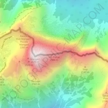
Name: Vrh Planje topographic map, elevation, terrain.
Location: Vrh Planje, Flitsch, Slowenien (46.44002 13.66151 46.44012 13.66161)
Average elevation: 1,785 m
Minimum elevation: 1,201 m
Maximum elevation: 2,663 m
Other topographic maps
Click on a map to view its topography, its elevation and its terrain.