
Municipio Acosta topographic map
Interactive map
Click on the map to display elevation.
About this map
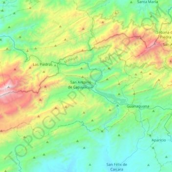
Name: Municipio Acosta topographic map, elevation, terrain.
Location: Municipio Acosta, Estado Monagas, Venezuela (10.01186 -63.93362 10.22316 -63.58444)
Average elevation: 824 m
Minimum elevation: 187 m
Maximum elevation: 2,559 m
Other topographic maps
Click on a map to view its topography, its elevation and its terrain.
San Antonio de Capayacuar
Venezuela > Estado Monagas > Municipio Acosta
San Antonio de Capayacuar, Parroquia Capital Acosta, Municipio Acosta, Estado Monagas, 6219, Venezuela
Average elevation: 708 m