
Gundagai topographic map
Interactive map
Click on the map to display elevation.
About this map
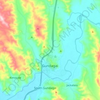
Name: Gundagai topographic map, elevation, terrain.
Average elevation: 309 m
Minimum elevation: 208 m
Maximum elevation: 622 m
Gundagai is an inland town with an elevation of 250 metres (820 ft). Almost all of the shire is located in the South West Slopes bio-region and is part of the Riverina agricultural region. The eastern part of the shire is considered part of the South Eastern Highlands bioregion.