
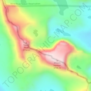
Hooker Glacier topographic map
Interactive map
Click on the map to display elevation.
About this map
Name: Hooker Glacier topographic map, elevation, terrain.
Average elevation: 3,420 m
Minimum elevation: 3,180 m
Maximum elevation: 3,802 m
Other topographic maps
Click on a map to view its topography, its elevation and its terrain.
Ranchester
États-Unis d'Amérique > Wyoming > Sheridan County
Ranchester, Sheridan County, Wyoming, 82839, États-Unis d'Amérique
Average elevation: 1,159 m
Park County
États-Unis d'Amérique > Wyoming
Park County, Wyoming, États-Unis d'Amérique
Average elevation: 2,257 m
Crystal Falls
États-Unis d'Amérique > Wyoming
Crystal Falls, Park County, Wyoming, États-Unis d'Amérique
Average elevation: 2,386 m