
Thank you for supporting this site ❤️
Make a donation
Make a donation
Le Bouloud topographic map
Click on the map to display elevation.
Thank you for supporting this site ❤️
Make a donation
Make a donation
About this map
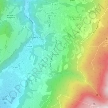
Name: Le Bouloud topographic map, elevation, terrain.
Average elevation: 725 m
Minimum elevation: 349 m
Maximum elevation: 1,515 m
Thank you for supporting this site ❤️
Make a donation
Make a donation
Other topographic maps
Click on a map to view its topography, its elevation and its terrain.
Saint-Nizier-d'Uriage
France > Auvergne-Rhône-Alpes > Isère > Saint-Martin-d'Uriage
Average elevation: 669 m
Les Seiglières
France > Auvergne-Rhône-Alpes > Isère > Saint-Martin-d'Uriage
Average elevation: 1,014 m
Villeneuve d'Uriage
France > Auvergne-Rhône-Alpes > Isère > Saint-Martin-d'Uriage
Average elevation: 575 m
Thank you for supporting this site ❤️
Make a donation
Make a donation