
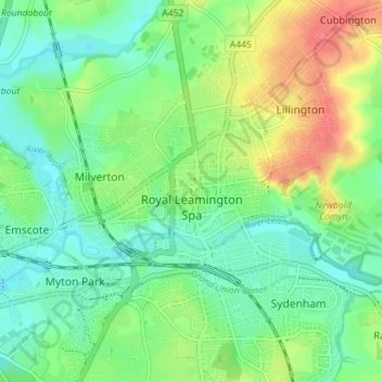
Royal Leamington Spa topographic map
Interactive map
Click on the map to display elevation.
About this map
Name: Royal Leamington Spa topographic map, elevation, terrain.
Average elevation: 66 m
Minimum elevation: 46 m
Maximum elevation: 100 m
Other topographic maps
Click on a map to view its topography, its elevation and its terrain.
Stratford-upon-Avon
Royaume-Uni > Angleterre > Warwickshire > Stratford-on-Avon
Stratford-upon-Avon, Stratford-on-Avon, Warwickshire, Angleterre, Royaume-Uni
Average elevation: 61 m
Nuneaton
Royaume-Uni > Angleterre > Warwickshire > Nuneaton and Bedworth
Nuneaton, Nuneaton and Bedworth, Warwickshire, Angleterre, CV11 5AB, Royaume-Uni
Average elevation: 101 m
West Midlands
Royaume-Uni > Angleterre > Warwickshire
West Midlands, Warwickshire, West Midlands Combined Authority, Angleterre, Royaume-Uni
Average elevation: 113 m