
Deer Park topographic map
Interactive map
Click on the map to display elevation.
About this map
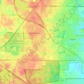
Name: Deer Park topographic map, elevation, terrain.
Location: Deer Park, Lake County, Illinois, États-Unis d'Amérique (42.15211 -88.12955 42.18501 -88.03867)
Average elevation: 253 m
Minimum elevation: 223 m
Maximum elevation: 276 m
Other topographic maps
Click on a map to view its topography, its elevation and its terrain.
Great Lakes
États-Unis d'Amérique > Illinois > Lake County > North Chicago
Great Lakes, North Chicago, Lake County, Illinois, 60088, États-Unis d'Amérique
Average elevation: 201 m
Mundelein
États-Unis d'Amérique > Illinois > Lake County > Mundelein
Mundelein, Lake County, Illinois, États-Unis d'Amérique
Average elevation: 231 m
Zion
États-Unis d'Amérique > Illinois > Lake County
Zion, Lake County, Illinois, 60099, États-Unis d'Amérique
Average elevation: 198 m