
Hochstadt (Pfalz) topographic map
Interactive map
Click on the map to display elevation.
About this map
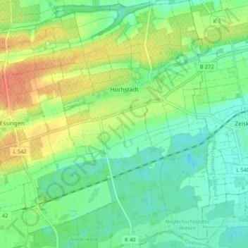
Name: Hochstadt (Pfalz) topographic map, elevation, terrain.
Average elevation: 133 m
Minimum elevation: 116 m
Maximum elevation: 160 m
Other topographic maps
Click on a map to view its topography, its elevation and its terrain.
Ramberg
Germany > Rhineland-Palatinate > Landkreis Südliche Weinstraße > Ramberg
Ramberg, Annweiler am Trifels, Landkreis Südliche Weinstraße, Rhineland-Palatinate, Germany
Average elevation: 409 m
Hainfeld
Germany > Rhineland-Palatinate > Landkreis Südliche Weinstraße > Hainfeld
Hainfeld, Edenkoben, Landkreis Südliche Weinstraße, Rhineland-Palatinate, 76835, Germany
Average elevation: 289 m