
Loonar topographic map
Interactive map
Click on the map to display elevation.
About this map
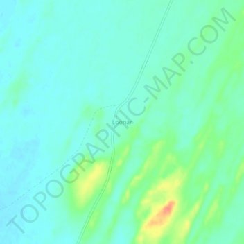
Name: Loonar topographic map, elevation, terrain.
Location: Loonar, Jaisalmer Tehsil, Jaisalmer District, Rajasthan, India (26.57597 70.24712 26.61597 70.28712)
Average elevation: 119 m
Minimum elevation: 107 m
Maximum elevation: 154 m
Other topographic maps
Click on a map to view its topography, its elevation and its terrain.
Sam
India > Rajasthan > Jaisalmer Tehsil
Sam, Jaisalmer Tehsil, Jaisalmer District, Rajasthan, 345030, India
Average elevation: 186 m
Jaisalmer Fort
India > Rajasthan > Jaisalmer Tehsil > Jaisalmer
Jaisalmer Fort, Main Chowk, Jaisalmer, Jaisalmer Tehsil, Jaisalmer District, Rajasthan, 345001, India
Average elevation: 238 m
Tanot
India > Rajasthan > Jaisalmer Tehsil > Tanot
Tanot, Jaisalmer Tehsil, Jaisalmer, Rajasthan, India
Average elevation: 107 m
Jaisalmer
India > Rajasthan > Jaisalmer Tehsil
Jaisalmer, Jaisalmer Tehsil, Jaisalmer District, Rajasthan, 345001, India
Average elevation: 242 m