
Hofheim am Taunus topographic map
Interactive map
Click on the map to display elevation.
About this map
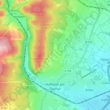
Name: Hofheim am Taunus topographic map, elevation, terrain.
Location: Hofheim am Taunus, Main-Taunus-Kreis, Hesse, Germany (50.07638 8.42146 50.12431 8.47436)
Average elevation: 183 m
Minimum elevation: 108 m
Maximum elevation: 340 m
Other topographic maps
Click on a map to view its topography, its elevation and its terrain.
Flörsheim
Germany > Hesse > Main-Taunus-Kreis
Flörsheim, Main-Taunus-Kreis, Hesse, 65439, Germany
Average elevation: 111 m
Hochheim
Germany > Hesse > Main-Taunus-Kreis
Hochheim, Main-Taunus-Kreis, Hesse, 65239, Germany
Average elevation: 123 m
Hofheim am Taunus
Germany > Hesse > Main-Taunus-Kreis > Hofheim am Taunus
Hofheim am Taunus, Main-Taunus-Kreis, Hesse, 65719, Germany
Average elevation: 198 m
Kriftel
Germany > Hesse > Main-Taunus-Kreis
Kriftel, Main-Taunus-Kreis, Hesse, 65830, Germany
Average elevation: 123 m
Eschborn
Germany > Hesse > Main-Taunus-Kreis
Eschborn, Main-Taunus-Kreis, Hesse, 65760, Germany
Average elevation: 146 m