
Yushu Tibetan Autonomous Prefecture topographic map
Interactive map
Click on the map to display elevation.
About this map
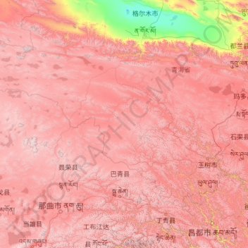
Name: Yushu Tibetan Autonomous Prefecture topographic map, elevation, terrain.
Location: Yushu Tibetan Autonomous Prefecture, Qinghai, China (31.60180 89.40222 36.28011 97.75779)
Average elevation: 4,472 m
Minimum elevation: 2,678 m
Maximum elevation: 6,488 m
With elevations above 3,600 metres (12,000 ft), the prefecture has a harsh climate, with long, cold winters, and short, rainy, and cool to warm summers. Specifically, in the Köppen system, the prefecture ranges from the alpine variation of the subarctic climate (Köppen Dwc), to a full alpine climate (Köppen EH), to a semi-arid climate (Köppen BSk). Most of the annual precipitation occurs from June to September, when on average, a majority of the days each month has some rainfall. The annual mean temperature in Yushu County, at an elevation of 3,690 metres (12,110 ft), is 3.22 °C (37.8 °F) and in Qumarlêb, in the northeast of the prefecture at 4,190 m (13,750 ft) elevation, −2.13 °C (28.2 °F). Sunshine is generous, ranging from around 2500 hours in the prefecture seat to 2780 hours in Qumarlêb.
Other topographic maps
Click on a map to view its topography, its elevation and its terrain.
Yellow River
China > Qinghai > Madoi County > Tso Kyaring
Yellow River, Tso Kyaring, Madoi County, Golog Tibetan Autonomous Prefecture, Qinghai, China
Average elevation: 4,268 m