
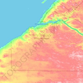
Whapmagoostui (Village) topographic map
Interactive map
Click on the map to display elevation.
About this map
Name: Whapmagoostui (Village) topographic map, elevation, terrain.
Average elevation: 101 m
Minimum elevation: -1 m
Maximum elevation: 232 m
Other topographic maps
Click on a map to view its topography, its elevation and its terrain.
Oujé-Bougoumou (Land)
Canada > Quebec > Eeyou Istchee
Oujé-Bougoumou (Land), Eeyou Istchee James Bay, Eeyou Istchee, Nord-du-Québec, Quebec, Canada
Average elevation: 372 m
Roggan River
Canada > Quebec > Eeyou Istchee
Roggan River, Eeyou Istchee, Northern Quebec, Quebec, Canada
Average elevation: 8 m
Lac Margie
Canada > Quebec > Eeyou Istchee
Lac Margie, Eeyou Istchee, Northern Quebec, Quebec, Canada
Average elevation: 318 m
Waswanipi (Land)
Canada > Quebec > Eeyou Istchee
Waswanipi (Land), Eeyou Istchee, Northern Quebec, Quebec, J0Y 3C0, Canada
Average elevation: 314 m
Mistissini
Canada > Quebec > Eeyou Istchee > Mistissini (Land)
Mistissini, Mistissini (Land), Eeyou Istchee, Nord-du-Québec, Quebec, G0W 1C0, Canada
Average elevation: 388 m
Chisasibi (Village)
Canada > Quebec > Eeyou Istchee > Chisasibi (Village)
Chisasibi (Village), Eeyou Istchee, Northern Quebec, Quebec, Canada
Average elevation: 96 m
Whapmagoostui (Category I Land)
Canada > Quebec > Eeyou Istchee > Whapmagoostui (Village)
Whapmagoostui (Category I Land), Whapmagoostui (Village), Eeyou Istchee, Northern Quebec, Quebec, Canada
Average elevation: 91 m
ᐙᔅᑳᐦᐄᑲᓂᔥ Waskaganish
Canada > Quebec > Eeyou Istchee > Waskaganish (Land) > ᐙᔅᑳᐦᐄᑲᓂᔥ Waskaganish
ᐙᔅᑳᐦᐄᑲᓂᔥ Waskaganish, Waskaganish (Land), Eeyou Istchee, Northern Quebec, Quebec, Canada
Average elevation: 15 m