Geolocate

Provincia de Chanchamayo topographic map

Interactive map

Click on the map to display elevation.

About this map

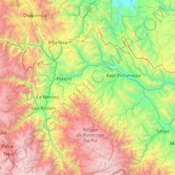
Name: Provincia de Chanchamayo topographic map, elevation, terrain.

Location: Provincia de Chanchamayo, Junín, Perú (-11.35023 -75.67091 -10.65340 -74.62294)

Average elevation: 1,927 m

Minimum elevation: 264 m

Maximum elevation: 5,014 m

Por su territorio viajan los ríos Perené y Pachitea. La altitud de la provincia varía desde los 500 a 1,930 m.s.n.m.

Other topographic maps

Click on a map to view its topography, its elevation and its terrain.

Ciudad Satélite

Perú > Junín > Ciudad Satélite

Ciudad Satélite, Provincia de Satipo, Junín, Perú

Average elevation: 768 m

Provincia de Chanchamayo

Perú > Junín > Perené

Provincia de Chanchamayo, Perené, Chanchamayo, Junín, Perú

Average elevation: 1,694 m

Junín

Perú > Junín

Junín, Perú

Average elevation: 2,657 m

Lago Junín

Perú > Junín

Lago Junín, Junín, Perú

Average elevation: 4,106 m