
Bahía de Banderas topographic map
Interactive map
Click on the map to display elevation.
About this map
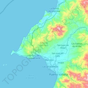
Name: Bahía de Banderas topographic map, elevation, terrain.
Location: Bahía de Banderas, Nayarit, México (20.67194 -105.53937 20.98643 -104.95742)
Average elevation: 155 m
Minimum elevation: 0 m
Maximum elevation: 1,431 m
Other topographic maps
Click on a map to view its topography, its elevation and its terrain.
Punta Mita
México > Nayarit > Bahía de Banderas > Corral del Risco > Punta Mita
Punta Mita, Corral del Risco, Bahía de Banderas, Nayarit, México
Average elevation: 8 m