
Husarö topographic map
Interactive map
Click on the map to display elevation.
About this map
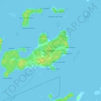
Name: Husarö topographic map, elevation, terrain.
Location: Husarö, Österåkers kommun, Comté de Stockholm, Suède (59.49928 18.82654 59.51499 18.86532)
Average elevation: 2 m
Minimum elevation: -4 m
Maximum elevation: 17 m
Other topographic maps
Click on a map to view its topography, its elevation and its terrain.
Norrtälje kommun
Norrtälje kommun, Comté de Stockholm, Suède
Average elevation: 13 m
Lagnö
Lagnö, Slut, Ekerö kommun, Comté de Stockholm, Suède
Average elevation: 2 m