
Boryeong-si topographic map
Interactive map
Click on the map to display elevation.
About this map
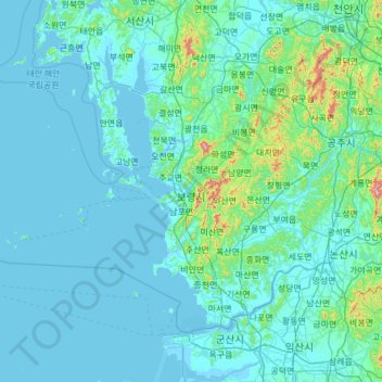
Name: Boryeong-si topographic map, elevation, terrain.
Location: Boryeong-si, Chungcheongnam-do, South Korea (36.16241 125.52337 36.53114 126.73910)
Average elevation: 50 m
Minimum elevation: -3 m
Maximum elevation: 815 m
Other topographic maps
Click on a map to view its topography, its elevation and its terrain.
Gwanchang-ri
South Korea > Boryeong-si > Gwanchang-ri
Gwanchang-ri, Boryeong-si, 33415, South Korea
Average elevation: 41 m